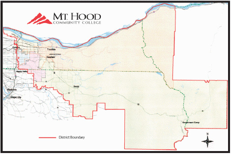
District

The Mt. Hood Community College district covers an area of about 950 square miles, with a population of more than 300,000. The district boundaries stretch as far east as the lofty peak of Mt. Hood and extend to the Wasco County line. It also reaches south into Clackamas County, covering the communities of Boring and Damascus. It extends west into the city limits of Portland. The northern boundary is the Columbia River, spanning from 33rd Street to Cascade Locks.
This area includes the high school districts:
- Corbett
- David Douglas
- Gresham-Barlow
- Parkrose
- Port of Cascade Locks
- Reynolds
- Centennial
- Oregon Trail District
Learn about MHCC education options for high school students
MHCC In-district Zip Codes
MHCC serves the communities in the following zip codes. If you have questions about MHCC District, please call 503-491-6422.
- Boring, 97009
- Bridal Veil, 97010
- Brightwood, 97011
- Cascade Locks, 97014
- Corbett, 97019
- Damascus, 97089
- Fairview, 97024
- Government Camp, 97028
- Gresham, 97030
- Gresham, 97080
- Happy Valley, 97086
- Portland, 97230
- Portland, 97233
- Portland, 97236
- Portland, 97238
- Portland, 97266
- Portland, 97269
- Portland, 97290
- Portland, 97292
- Portland, 97294
- Portland, 97328
- Rhododendron, 97049
- Sandy, 97055
- Troutdale, 97060
- Welches, 97067